‘Desertification’ or ‘Greening’? Human-Environment Relationships in the Face of Climate Variability: Case Studies in Mauritania and Senegal. PIs Stefanie Herrmann, Thomas K. Park, Mamadou Baro, and Randy Gimblett.
PRIOR NSF SUPPORT
Thomas Park and Mamadou Baro were PI and Co-PI on the “African Cities Project” (NSF grant no. EAR9817743) from 1998 to 2003, a project combining social science and remote sensing. A consistent and replicable methodology was developed for using remote sensing image analysis as a basis of stratification of African cities into classes of housing types and their rough rates of development, with the aim of facilitating comparative study of rapid urbanization in developing countries. The methodology was developed in conjunction with local partners in Morocco, Senegal, Mali, Niger, Tanzania and Botswana, and demonstrated a successful household sampling strategy for socio-economic data based on pixels whose precise coordinates are known; a methodology that makes spatial monitoring of urban change feasible at low cost (Park and Baro, 2003 ; Marsh et al., 2003).
INTRODUCTION
Beginning in the late 1960s, the West African Sahel zone has repeatedly made headlines for a number of – potentially related – environmental and economic problems, including frequent droughts, impoverishment of the natural resource base, unsustainable land use and management practices, rural out-migration and stagnation of rural development (Raynaut et al., 1997). Changes in land cover have been identified as both causes and consequences of these problems. While these changes are often referred to as ‘desertification’, there has been a lack of consensus among scientists over the exact meaning of this notion, the mechanisms governing it, and the extent of the problem in the Sahel (Herrmann and Hutchinson, 2005). Development interventions aimed at controlling desertification have produced but few tangible results, and a significant part of this failure has been attributed to deficiencies in the science that guided these interventions, particularly the imperfect understanding of the complexity of the situation.
Contrasting with the widely held assumption of progressing desertification, a number of research projects carried out in the last decade found no evidence of irreversible deterioration of the resource base (Prince et al., 1998; Tucker and Nicholson, 1999; Niemeijer and Mazzucato, 2002; Tiffen and Mortimore, 2002). Recent remote sensing-based studies have even shown an overall greening trend in the Sahel (e.g. Eklundh and Olsson, 2003; Olsson et al., 2005; Herrmann et al., 2005), which might indicate that some positive developments have been going on. However, the meaning of ‘greening’, sometimes hastily interpreted as a recovery of the natural resource base, is as vague as that of ‘desertification’, and its implications on the ground are far from clear and unambiguous. Some local success stories in natural resource management, which led to a rehabilitation of soil and vegetation conditions, have been reported from the ground (e.g. Reij et al., 2005; Mortimore, 2005), but so far there is little information on the scale, the driving forces behind and larger impacts of those developments (CILSS, 2004).
We propose a project to (1) investigate the biophysical realities of the opposing trends of desertification and greening respectively in four selected study sites in Mauritania and Senegal, (2) evaluate their ecological, social and economic implications, and (3) model relationships among their human and natural driving forces, building on recent advances in the conceptual understanding of the functioning of complex systems (Waldrop, 1992; Axelrod and Cohen, 1999) and technological/methodological developments in geospatial modeling and agent based simulation (Gimblett, 2002). In the proposed project, the discussion of desertification and greening is positioned in the broader debate of land use and land cover change (LUCC), a debate that is driven by the concerns over human-induced impacts on the environment. In the case of the Sahel, the respective roles of human agents in triggering or buffering land cover change and of climatic factors, as well as the interplay between both, remain largely unresolved. In addition, neither human nor climatic factors can be treated as constant forces: socioeconomic and political conditions in the Sahel have been changing at timescales of years to decades, and global climate change is likely to affect Sahelian rainfall variability and aggravate drought impacts, posing new challenges to this region already under stress (IPCC, 2001). In view of progressing global climate change, understanding the relationships among land cover, land use, and climate is particularly timely. Identifying economically viable and environmentally sustainable land use strategies under climate variability, which improve rather than degrade the natural resource base, may hold important lessons for the adaptation to the escalating effects of climate change in marginal dryland environments.
GOALS AND OBJECTIVES
The overall goal of the proposed project is to develop empirical evidence that can inform our understanding of the relationships among land use, land cover, and people’s livelihoods in the in the face of rainfall variability and unpredictability in the West African Sahel. Ultimately, this will contribute to enhancing theoretical understanding about human and natural system processes and relationships in dryland environments, which might be used to help communities and aid agencies to make more informed resource management decisions. While we are primarily interested in the functioning of the human-environment system as a whole, that is, the interplay among a range of biophysical and socioeconomic variables, a solid understanding of the behavior of the individual variables over time is valuable before trying to integrate them. To this end, we will address the following, more specific objectives in four selected study sites:
Objective 1: Measure land cover dynamics and evaluate land use by means of remote sensing. This objective addresses primarily the imprints of the human-environment system on the landscape and will provide us with a macro view of spatial and temporal patterns of land cover changes that took place during the past 25 years in the study sites and the surrounding area. The synoptic perspective offered by a combination of high spatial resolution (Landsat, Quickbird and aerial photography, as available from USGS) and high temporal resolution (MODIS, AVHRR) imagery will be used as a cost-effective means of (a) assessing the current land cover and differentiating between different land use types (b) identifying trajectories of change over time, particularly in the vegetative cover, and (c) locating pockets of change trajectories that are coherent in time and space.
Objective 2: Reconstruct current and past land use decisions and evaluate the socio-economic and political frameworks in which they have been taken. This objective focuses on the land use patterns of different natural resource user groups and aims at understanding the rationale behind their land use and management decisions in past and present. We will (a) conduct field surveys on the perspectives of villagers and local experts on their land use and land management strategies (resource use, conservation, and rehabilitation) and factors influencing their decision making with respect to these, (b) review any available previous assessments and the history of state projects and subsidies over time, and (c) collect and exploit socioeconomic and demographic indicators from national databases to support the analysis with quantitative data.
Objective 3: Establish relationships between land use and land cover change and simulate land cover change under different climatic and management scenarios. An agent-based model (ABM) will be constructed with natural resource user groups and (political and economic) institutions as agents. The ABM will be integrated into a rasterized Geographic Information System (GIS), representing the biophysical environment with which, and inside which, the agents interact. The behavior of the agents will be derived from the survey data (objective 2), and the biophysical environment modeled from the spatio-temporal land cover information (objective 1) complemented with rainfall records and soil maps. After evaluating the ability of the model to reproduce observed land cover changes over the past 25 years, we will use it to simulate land cover change under different climatic and management scenarios.
PRELIMINARY WORK AND SELECTION OF STUDY SITES
Results of a remote sensing-based study of the relationships between recent vegetation greening and rainfall in the Sahel show rainfall as the dominant causative factor in vegetation dynamics and furthermore suggest the presence of another, weaker, causative factor independent of rainfall (Herrmann et al., 2005). This factor was revealed through regression of vegetation greenness (Normalized Difference Vegetation Index – NDVI) on three-monthly cumulative rainfall estimates and analysis of trends in NDVI residuals, using an 8-km resolution NOAA-AVHRR NDVI time series for the period 1982 to 2003 and a 2.5° resolution GPCP satellite rainfall time series for the same time period. We hypothesize that this second causative factor is human-induced and might reflect the effects of land use practices and management decisions. Areas that stand out by a recovery of vegetation greenness beyond what would be expected from the increase in precipitation include parts of Senegal, southeastern Mauritania, some areas in Mali, the Central Plateau of Burkina Faso, the Tahoua and Maradi regions of Niger, and areas in Chad. Areas in which a negative development (i.e. vegetation greenness trends falling behind what would be expected from precipitation trends) seems to have taken place are found in northern Nigeria and Sudan (fig. 1). The coarse resolution of the datasets, however, is likely to obscure patterns of greening fine enough to help explain its causes.
At the same time, a still ongoing study on “Success Stories in Natural Resource Management in the Sahel” (CILSS, 2004) has investigated several cases of village territories across the Sahel where local successes in natural resource management became evident over the past two decades. Through Gray Tappan, who is involved with the CILSS study and a consultant to the proposed project, we will be able to create synergies between both studies, that is, share high resolution datasets and compare findings from different sites.
![]()
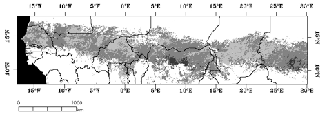
Fig. 1: Trends in residual NDVI throughout the period 1982 to 2003, based on regression of monthly maximum NDVI on three-monthly cumulative rainfall (GPCP estimate) [simplified from Herrmann et al., 2005]. Areas in Mauritania and Senegal in which we propose to select study sites are outlined with dashed lines.
We propose to select four study sites within two contrasting agro-ecological regions, one in southeastern Mauritania (encompassing Hodh Ech Chargui and Hodh El Gharbi) and one in eastern Senegal (northern Tambacounda and Matam), which both include some areas characterized by positive greening trends (fig.1), however bearing in mind that different patterns of trends might be revealed at a finer resolution. Southeastern Mauritania is predominantly pastoral, whereas eastern Senegal is an agro-pastoral region. We have good academic contacts with both countries, with Mauritania due to an International Memorandum of Agreement for research collaboration between the University of Arizona and the Université de Nouakchott and with Senegal due to a history of collaboration with the Centre de Suivi Ecologique in Dakar.
In each of the two regions, two study sites of approximately 20 x 20 km will be selected – one showing significant greening and a control site outside of the greening zone – based on considerations of accessibility and availability of data (such as rainfall records, previous land use assessments and density of documentation over the past 25 years).
BACKGROUND
Desertification and Greening in the context of the Land Use and Land Cover Change discussion
Land use and land cover change emerged as a central issue in the broader debate of global change, a debate that has its origins in the concerns about human-induced impacts on the environment and their implications for climate change (Lambin et al., 1999; Verburg and Veldkamp, 2005). Land cover change is driven largely by land use and management practices, which in turn are a function of environmental opportunities and constraints but also of a complex web of social, economic and political processes. Large- and medium-scale land cover conversions in tropical ecosystems, such as deforestation, have so far received the bulk of attention (e.g. Skole and Tucker, 1993), due to their prominent role in global biogeochemical cycling, one of the ‘big issues’ of land use and land cover change science. Land cover modifications, by contrast, are more subtle and therefore more difficult to detect, but are no less a factor in global change.
Important manifestations of land cover modifications are land degradation and desertification. While land degradation is generally agreed on as the “reduction or loss of the biological and economic productivity and complexity of terrestrial ecosystems, including soils, vegetation, other biota, and the ecological, biogeochemical and hydrological processes that operate therein” (UNCCD, 1994: p.5), the concept of desertification – or “land degradation in arid, semi-arid and dry sub-humid areas resulting from various factors … ” (UNCCD, 1994: p.4) – has been the subject of a heated debate (see Thomas and Middleton, 1994; Herrmann and Hutchinson, 2005). Particularly, the respective roles of natural and human factors in causing and sustaining it are still unresolved. Proponents of an imminent environmental disaster caused by increasing and irreversible desertification due to man’s action (Verstraete and Schwartz, 1990; Le Houerou, 2002; Hein and de Ridder, 2006) have been challenged by desertification skeptics. The latter question the causation and extent of the problem, or its existence altogether, using evidence from empirical case studies on the ground (Mortimore and Adams, 2001; Tiffen and Mortimore, 1992 and 2002; Niemeijer and Mazzucato, 2002) or multi-temporal satellite imagery (Tucker and Nicholson, 1999; Prince et al., 1998; Eklundh and Olsson, 2003; Seaquist et al., 2006). Some have postulated a "greening" of the Sahel (e.g. Pearce, 2002; Olsson et al., 2005). Within this debate, it is often presumed that “greening” is positive in climatological, ecological, and economic terms and equals a process of land rehabilitation, whereas a decline in greenness is negative and equals desertification. However, these relationships remain unproven. Land cover change towards “greener” conditions may as well be produced by encroachment of invasive vegetation species that pose a threat to local agricultural systems, and thus mask a transition towards a new, not necessarily better, ecosystem state. The valuation of land cover change as positive or negative has a multitude of meanings whether viewed from the perspective of the resource user or within its local, regional or global ecological context (Warren, 2002).
The Sahel – a prime example of the ‘desertification crisis’
The West African Sahel is a densely populated, semi-arid band, which stretches some 5,000 km along the southern edge of the Sahara desert. It forms a transition zone between the arid Sahara and the subhumid Soudanian and Guinean savannas with a sharp north-south gradient in rainfall and land cover. Mean annual rainfall figures of 200 mm in the north to 600 mm in the south hide enormous inter-annual fluctuations, which make parts of the region resemble a desert in some years and a lush grassland in others.
Concerns about a progressive desiccation in the Sahel have a long history (Bovill, 1921; Stebbing, 1935). Speculation about drying trends is confounded by periods of relative abundance in rainfall, during which such concerns subside quickly. The worst and longest recent drought hit the Sahel in the late 1960s, after a series of favorable rainfall years which had encouraged an expansion of agriculture towards the drier north. The drought struck the newly independent Sahelian nations unexpectedly and, combined with rapid population growth and deteriorating terms of trade, propelled the whole region into a state of crisis. Media reports on recurring famines and large scale emergency interventions helped to establish an image of a vulnerable population, victimized by the vagaries of their natural (and political) environment. More recently, a counter narrative has emerged of relatively resilient populations, who have developed strategies to creatively cope with conditions of environmental, economic and demographic stress. Examples from different Sahelian regions can be found, among others, in Batterbury and Forsyth (1999), Reij and Waters-Bayer (2001), and Mortimore (1989 and 1998). In this countering view, rather than irrationally overusing their natural resources, land users have a strong interest and expertise in conserving or improving soil fertility and making optimal use of pastures under conditions of disequilibrium. There is little doubt, however, that temporary and chronic shortages of capital resources and unresolved land tenure issues encourage people to adopt land use practices which are aimed at meeting their immediate needs even if that means compromising the long-term stability of the resource base.
Ecological conditions and degradation factors
Not only scarcity but also variability and unpredictability of rainfall at interannual and interdecadal time scales are defining characteristics of drylands, and the Sahel is considered the most striking example of rainfall variability worldwide (Hulme, 2001). Against this backdrop of natural variability, any anthropogenic contributions to desiccation and desertification are very difficult to identify.
Moisture availability is the major limiting factor for primary production in much of the Sahel. Annual rainfall is concentrated in a few humid months, increasing from north to south. It triggers the growthof annual plants for livestock and allows for seasonal rainfed agriculture in favored locations. At the same time, the sometimes heavy downpours have a considerable potential for inducing erosion after the dry season. In drought years, rainfall deficits together with high potential evapotranspiration in the Sahelian summer might render the time available for vegetation growth too short for agricultural production. Although rainfall variability is a normal component of dryland climate, the rainfall deficits experienced in the Sahel since the late 1960s were chronic into the 1990s until rainfall improved, with the years 2003 and 2006 being a particularly good rainfall years for at least some regions. This countersthe general perception of increasing drought since the beginning of the century (Le Borgne, 1990) and makes it difficult to tell whether the long period of below-average rainfall years was part of the normal climate variability or indicates an irreversible change towards drier climatic conditions in the Sahel (Nicholson, 2000, 2001 and 2005).
Highly variable rainfall has repercussions on the vegetation cover, which reflects not only rainfall totals, but also the onset and length of the season and the number of days with rain. In recent years, delays in the onset of the rainy season were observed across the Sahel, which affected the farming sector. Another factor that determines both natural vegetation cover and human land use are soil conditions. The dryland climate makes soil moisture more significant than soil fertility, particularly in the more arid parts of the Sahel. Sandy soils with their high permeability and moisture retention capacity make better use of precipitation than more compact soils, although the latter are often more fertile. However, deep plowing with draft animals or machines allows for increased infiltration and eases root penetration (Raynaut et al., 1997). While soil fertility decline as a result of overcultivation has been described as widespread and serious problem throughout the Sahel (Koning and Smaling, 2005), Mortimore and Harris (2005) argue that soil fertility depends heavily on land use and management, with some practices contributing to maintaining or even improving soil fertility.
In the proposed study region in southern Mauritania, sandy soils (arenosols) and consolidated sand dunes (regosols) prevail. Arenosols have good pasture value and, particularly on alluvial deposits bordering valleys, offer agricultural opportunities as well. Essential annual crops can be improved with manure. Regosols occur in association with lithic formations or shifting sands and support acacia trees and shrubs and an open vegetation of perennial and annual grasses between them. These formations are mostly used as winter ranges (FAO, 1988). The study region in eastern Senegal is situated on sandstone plateaus covered by shallow loamy and gravelly soils, with deep leached tropical ferruginous soils in the valleys. Tree and woody savannas prevail in the southern part, shrub savannas and bushland in the north (Tappan et al. 2004). Agricultural potential is poor in the north, which is mostly used as grazing land, whereas woody savannas are dotted with agricultural fields further south.
The Sahelian ecosystem responds dynamically to rainfall variability and anthropogenic pressure. According to recent ecological understanding, drylands function as non-equilibrium systems with limited capacity for internal regulation and greater potential for transit among multiple equilibrium points, once ecological thresholds are crossed (Briske et al., 2003; Behnke and Scoones, 1993; Westoby et al. 1989). These thresholds bring about discontinuous and possibly non-reversible changes: For example, across the Sahel, a large number of woody species disappeared in the 1970s as a consequence of lowering groundwater table and increased exploitation and felling of trees, a fundamental source of wood and other products, by a growing population (Raynaut et al. 1997; Gonzalez, 2001). Trees are an important long-term investment, however their protection is compromised when immediate survival takes priority. Likewise, the herbaceous cover suffers not only from a moisture deficit in drought years, but also from increased grazing pressure on sparsely vegetated pastures. While regeneration of herbaceous vegetation seems possible, provided that seedbanks are still intact, upon return of more favorable rainfall conditions and under land use practices that focus on soil and water conservation, its composition might be modified by certain species disappearing and others rapidly growing. For example, the extensive growth of euphorbia at the expense of more ‘useful’ species seems to present a problem in southern Mauritania (oral communication: Birane Wane). Woody vegetation is more difficult to regenerate than herbaceous vegetation, at least at the timescales we are dealing within our study. As trees fulfill an important role in protecting the soil and producing organic matter, their loss makes the land more susceptible to degradation, particularly the effects of aeolian deflation (Raynaut et al., 1997). Destruction of the vegetation cover by a combined effect of climatic uncertainties and human pressure, can in turn aggravate aridity and induce a positive feedback cycle when soil moisture balance and albedo are modified at a larger scale (Charney et al., 1975; Folland et al., 1991).
Natural resource management and land use practices
In the face of climatic uncertainties and a vulnerable environment, Sahelian rural land use systems and livelihoods have emerged as “more resilient than expected” (Mortimore, 1998: p.111). If we believe the more pessimistic predictions of desertification, farming systems and livestock markets would have collapsed many years ago and entire areas of the Sahel depopulated. That this dim scenario has not materialized demonstrates that populations have, at least to some extent, adapted to conditions of environmental, economic and demographic stress and found ways to cope and minimize risk of loss of their livelihoods.
Natural resource management is a complex issue in the Sahel, as in most parts of Africa, due to its profoundly political character (Benjaminsen and Lund, 2001). Tenure relations attached to natural resources are very dynamic, because they involve different groups of resource users, such as pastoralists and farmers, as well as the interests of the political elite. Rural livelihoods and wealth depend heavily on access to natural resources, defined by tenure relationships, which often are objects of politicization and continuous negotiation (Toulmin et al., 2002). Most tenure systems are characterized by multiple tenures, with several users holding different rights to the resources of the land. Access to and use of resources is therefore dependent on time of year and specific circumstances.
While research has stressed the importance of institutional factors (i.e., economic policies, land tenure relationships, market developments) in conditioning and constraining natural resource management (Batterbury and Warren, 2001; Batterbury et al., 2002), day-to-day management is practiced and decisions are made within this institutional framework at the level of individual households and groups of households. Recently, some empirically based local-level studies offered new insights into production and livelihood systems in the Sahel (Mortimore and Turner, 2005; Ellis, 1998). Mortimore in particular, without denying the precariousness of the situation, stresses the existence of internal adaptive capacities of rural households in dealing with rainfall variability and uncertainty and other productivity constraints (Mortimore 1989 and 1998). The allocation of labor, skills and capital is playing a central role in managing agricultural and natural biodiversity and maintaining soil fertility. Furthermore, the integration of livestock as a supplier of soil nutrients and diversification away from agriculture are important strategies for coping with risk (Batterbury, 2001). As for pastoral resources, the rationale of herding is based on opportunism rather than static carrying capacities. Pastoralists take advantage of good years by building their herds, even though heavy losses will be suffered in drought years (Behnke and Scoones, 1993). It has also been found that, in the face of environmental crisis, the rural population actively engages in the conservation of soil and water resources using simple and effective techniques, for example planting pits to improve water retention and rock dams to rehabilitate erosion gullies (Reij and Waters-Bayer, 2001; WOCAT, 2007). How generalizable and widespread these examples are, and which conditions favor them, is unknown; however, it has become clear that land use practices have not only contributed to desertification in some areas, but also to the conservation and regeneration of resources. Thus, environmental degradation may be, in large part, a question of perception, with some resources being lost or degraded and others being enhanced by land use practices (Johnson and Lewis, 2007).
The proposed study sites are located in zones shared between pastoralism and agriculture. Southern Mauritania is predominantly pastoral. Herders and farmers depend on annual rains, and delays in the beginning of the rainy season can cause large losses and lead to mass migrations from the Hodh Ech Chargui and Hodh El Gharbi southward into Mali. During the past 20 years, the rural economy has been affected greatly by the impacts of drought and neglect of the rural sector by government planners. The effects of recurrent droughts have forced shifts in patterns of herd movement and ownership (towards urban investors who hire herders) and increased pressures on land also used for farming. Rainfed dryland cropping, called dieri, is practiced from July through September in those years and areas that receive sufficient precipitation, their extent varying from year to year. Millet and sorghum are the principal rainfed crops. Land ownership is usually vested in the clan or village chiefs and distributed to family units having the right of usufruct (FRD, 1990).
Eastern Senegal is an agro-pastoral region with pastoralism dominating towards the north on shallow soils over lateritic plateaus, whereas further south agriculture driven by Wolof and Serer settlers from the west has been expanding into pastoralist and sedentary grazing lands. Fuelwood logging and charcoal production have further decimated the wooded savannas, resulting in the exposure of bare degraded soils. Agriculture is mostly geared towards subsistence with a mosaic of sorghum, millet and niebe bean fields, following crop rotation schemes. Only in the past couple of decades has commercial production of peanuts and cotton expanded into the region (Tappan et al., 2004).
Conceptual issues in modeling human-environment interactions: complexity – diversity – dynamics
Stern (1993, p. 1897) comments on the study of human causes of environmental change: “Scientific progress has been slowed by a futile debate about which of these factors is the most important driving force, a debate that rests on the erroneous assumption that the contributions of these forces to anthropogenic change can be assessed independently,” and comes to the conclusion that “what has become clear is that the driving forces interact – that each is meaningful only in relation to the impacts of the others…”. This sums up the complexity of just one dimension in human-environment interactions, with the biophysical dimension being equally complex and modified by multiple feedback mechanisms.
Simple cause and effect relationships, such as the impact of population growth on land cover, rarely provide adequate answers to questions of land cover change (Lambin and Geist, 2001; Lambin et al., 2001). Rather, case study evidence suggests a diversity of possible pathways of change in real world situations. Thus, depending on a range of other factors, increases in population and the resulting pressure on the land can contribute to degradation of the resource base in one case, or, in another case, according to a Boserupian view, the same pressure can have potentially positive outcomes for both welfare and the environment due to the availability of additional labor (Boserup, 1965). In addition to complex local socio-economic and biophysical factors that condition human-environment relationships in a particular locality, external factors also play an important role. Rural Sahelian economies are not isolated from the rest of the world, but embedded in regional and global institutions: markets, micro- and macro-policies, and tenure arrangements. All these are part of the framework in which individual land use decisions are made in response to local socio-economic and biophysical conditions. These create a set of opportunities and constraints that is highly diverse, both in space and in time (Scoones, 2001). Response strategies by individual land users are equally diverse, depending on capital endowments, expected outcomes, or traditions. Staying with the example of population growth, responses can range from demographic (e.g. out-migration, fertility reduction; Bilsborrow, 1987) to technological (Boserup, 1965), or to local changes in tenure arrangements (Bilsborrow and Ogendo, 1992). To complicate matters, these responses can occur sequentially or simultaneously (Lambin et al., 2003).
The complexity inherent in the human-environment system and the diversity of real world situations, even within a local setting, pose a real challenge to modeling human-environment interactions and resulting land cover changes, and this is reflected in our choice of research methodologies and tools. Simulation is a rather new way of thinking about complex social and natural processes and only began to be used widely since the 1990s (Gilbert and Troitzsch, 1999; Parker et al. 2002). We will use agent-based modeling (ABM), an approach that has its origins in complexity theory (Waldrop, 1992) and artificial intelligence, integrated in a Geographic Information System (GIS), a product of the development of spatial science (Fischer and Getis, 1997), to explain and model land use and land cover changes and evaluate them as degradation or regeneration. The agent-based perspective is centered on the nature of land use decision making by individual agents, which can be extended family groups or institutions, embedded in an environment, in our case represented by the biophysical environment. The spatial dimension provided by the GIS allows us to address not only the question of WHY things happen, but also of WHERE they happen.
METHODOLOGY AND PLAN OF WORK
Part 1: Analysis of land cover dynamics by means of remote sensing
Satellite imagery has proven to be a reliable and cost-efficient source of global land cover information (Cihlar, 2000), most notably in poorly accessible areas where few other sources of information exist. Remote sensing data has also been widely used in land degradation and desertification assessments at all scales (e.g. Prince et al., 1998; Palmer and van Royen, 1998; Weiss et al., 2001). We will use established image processing techniques to extract information on land cover change and modification, especially with respect to density and composition of the vegetation cover. This process will be iterative, utilizing ground survey and ancillary data to validate and fine-tune the analyses.
Data requirements
The study will make use of a multi-sensor approach, which combines the advantages of fine spatial resolution with those of fine temporal resolution data. Fine spatial resolution data, provided by Landsat TM and ETM+ sensors (30m), will be used for identification of prominent land cover and land use types at discrete points in time and very fine spatial resolution data from Quickbird (0.6-2.4m) and Corona (5m) (previously analyzed imagesubsets can be made available for some sites through Gray Tappan, USGS) to support ground validation. Fine temporal resolution data, available from MODIS at a 16-day repeat cycle since 2000 with a spatial resolution of 250m will provide trajectories of change in vegetation cover over time.
Preprocessing
Whereas MODIS tiles are available as ready ‘data products’, already corrected for undesired noise and even converted into vegetation indices, certain preprocessing steps are required before analysis of the Landsat scenes:
1) Atmospheric correction: The Cosine of the Solar Zenith Angle Correction (COST) model will be used to correct for noise induced by the atmosphere (Chavez, 1996). The COST model is an easy-to-implement dark object subtraction technique, which does not require additional ground or atmospheric measurements. It is therefore suitable for multi-temporal studies which lack historical ground and atmospheric information; all the while it has been found to perform just as well as more sophisticated models (Chavez, 1996).
2) Radiometric calibration: Before extracting vegetation indices, image digital numbers will be calibrated into values of spectral band reflectances using the nominal minimum and maximum radiance values for each satellite.
3) Geometric rectification: A second-degree polynomial geometric model and nearest neighbor resampling will be used to geometrically register the Landsat TM and ETM+ scenes to a root mean square (RMS) error of less than 1 pixel to avoid errors in change detection introduced without accurate geometric rectification.
4) Extraction of vegetation indices: The Normalized Difference Vegetation Index (NDVI) (Tucker, 1979; Rouse et al., 1974; Tucker et al., 1985; Myneni et al., 1995), the most widely used remotely sensed vegetation index, which makes use of the different reflectance properties of green vegetation and bare soil in the red and infrared spectral regions, will be computed from spectral band reflectances. In addition, we will calculate the Soil Adjusted Vegetation Index (SAVI) (Huete, 1988), which minimizes soil brightness influences on the vegetation greenness estimate, and the Enhanced Vegetation Index (EVI) (Huete et al., 2002).
Change detection
Land cover change can take two forms: conversion from one land cover category to another – the threshold of change depending on the number of categories used – and more subtle land cover modifications which do not result in conversion between categories (Jansen and Di Gregorio, 2002 ; Lunetta et al., 2002). For the detection of desertification/land degradation and greening/land rehabilitation, we are primarily interested in changes in the vegetative cover in the form of both conversions among cropland, pasture and natural vegetation, and subtle modifications of vegetation composition. Remotely sensed vegetation indices, as synoptic measures of overall greenness, do not yield any information on the composition of the vegetation. Therefore, standing alone, they are not very helpful in detecting subtle shifts in vegetation, which do not alter the overall greenness. Differences in phenology, however, have been successfully used to differentiate between vegetation types such as herbaceous and woody vegetation (e.g. Lu et al., 2003). We will exploit the phenology aspect by:
(1) Performing a change vector analysis on the MODIS NDVI and EVI datasets covering the entire period from 2000 to 2005. This method has been tested by Lambin and Strahler (1994) for a time series of AVHRR NDVI images of a part of West Africa and revealed different trajectories of change.
(2) classifying annual ‘image cubes’ made up of stacked 16-day MODIS vegetation indices (the notion of ‘image cube’ actually is from hyperspectral imaging (Goetz et al., 1985), but we will use it here with a temporal instead of spectral dimension). The stack of 16-day MODIS vegetation indices will be complemented with phenological indicators (such NDVI seasonal integral and amplitude, start and duration of growing season). A preliminary unsupervised classification will be carried out on the image cubes, which will be fine-tuned based on ground truth collected during a field visit and with the help of a fine resolution current ETM+ image.
(3) carrying out a post-classification change detection (= image differencing) on the classified image cubes.
In addition, an assessment of changes with finer spatial detail will be obtained from the analysis of Landsat scenes at bi-yearly or longer intervals, especially in years with exceptionally low or high rainfall, covering a total period from 1982 to 2005. We will acquire images from the end of the growing season (August/September), when cultivated fields are still distinguishable from natural vegetation but cloud cover is already likely to be less frequent. Where available from previous USGS studies, the set of Landsat images will be complemented Quickbird and CORONA images and aerial photography. Pre- and post-classification change detection will be done on different vegetation indices, the spectral bands, albedo.
Integration of ancillary data
An important aspect of the study of desertification is the distinction between the temporary effects of drought on the vegetation cover and long-term effects of degradation. During drought years, the greenness of the vegetation can drop significantly. Drought conditions, however, are not synonymous with land degradation, although their short term effects on the vegetation cover can look similar. Once the rains return, the difference between drought and land degradation becomes more obvious. In the drought case, vegetation can recover quickly, but in the land degradation case, a return of the rains will not result in a re-establishment of the original vegetation cover, because the ecosystem might have passed into a different state (see Schlesinger et al., 1990). Therefore, in order to draw conclusions about land degradation, vegetation greenness data has to be “normalized” to rainfall conditions. We will implement, at a local scale, a methodology of estimating the effects of rainfall on vegetation dynamics which has already been applied to the entire Sahel region at a coarse resolution (Herrmann et al., 2005). However, results of this kind of analysis are likely to be scale dependent and sensitive to the spatial resolution of the datasets employed. We anticipate applying this procedure at a local scale using MODIS images and rainfall surfaces constructed from ground measurements (from NOAA NCDC: http://www.ncdc.noaa.gov/oa/ncdc.html) to reveal a finer pattern of likely causes of changes in vegetation greenness, at a level of aggregation that can be matched with georeferenced socio-economic data. Constraints may arise, however, from the fact that these MODIS resolution datasets are available for a shorter time period than the previously used AVHRR datasets.
Part 1 will be carried out mostly at NCAR with support from USGS, using image processing software packages ERDAS and ENVI, and TIMESAT, a software that is specifically designed for the extraction of phenological characteristics (Jönsson and Eklundh, 2002 and 2004). A ground validation campaign for the classification of the most current Landsat image will be conducted parallel to the resource user surveys in Mauritania and Senegal.
Part 2: Assessment of land use and management from a resource user perspective
Information on the human dimension of land use and land cover change and degradation issues will be collected focusing on four categories of key informants to capture the larger socio-economic context in which these decisions are made. This research will emphasize group rather than household-level decision making about natural resource use. We define resource user groups as villagers who collaborate over access to and use of specific natural resources, such as wood, cropland, water, as well as foraging of natural products and grazing resources. We will select villages in the study areas and then assemble four small focus groups per village (5 people in each group) stratified by age (20-35 and 36+) and gender, while representative of different wealth categories.
Initially, meetings with community leaders will be used as an occasion to draw representative samples of key informants, who know the study region well and make use of its resources. Women and men use these areas intensively in both overlapping and complementary ways. The older generation will have the advantage of being able to recall a greater range of climatic variation while the younger generation may be using the area in less traditional ways. In most of the Sahel, women are more free to talk when interviewed apart from the men, though in some villages they are exceptionally outspoken even in mixed company.
Data collection
Our data collection efforts will concentrate on the types of land use, acquisition of estimates of the number and proportion of households pursuing particular strategies (e.g. types of agriculture, livestock management or natural product collection), elicitation of the subgroup memberships within the village that determine tenure and land access, the circumstances which impact strategic preferences (physical, demographic, socio-economic), and the rankings of each land use and management strategy by each key informant for a small range of climatological conditions (e.g. recollection of strategies pursued in a small set of recent years presenting diverse rainfall patterns in the study region). We will also try to roughly map out that usage using informants and GPS units to link our informant based data with our remote sensing data.
Questionnaire development and focus group discussions
We will develop a standardized questionnaire to be administered to the key informants individually (the members of the four focus groups), to address the above aims as well as to assess past (last 20 yrs) human activities that cause changes in land cover as well as people’s perception of environmental change and their role in it. Four themes will be addressed (in historical perspective): (1) natural resource use, (2) perception of changes in the environment, (3) livelihood strategies including migration, and (4) changes in – objective and subjective – well-being. The informants will be asked to estimate the situation of their extended family and village rather than their household. The questionnaires will provide the basis for open ended discussions with the focus groups.
These focus group discussions will try to extract some consensus on three key themes: (1) how much diversity there might be in decision making in the course of the year and across years, (2) the numbers of people in the village pursuing particular strategies, and (3) the factors impacting strategic choices. We will also ask the groups to map out the key areas used within the study area and compare their condition over time. Each individual will then be asked to rank order livelihood strategies in the study area according to several criteria (e.g. potential benefits, labor demands, risk/reliability, and actual usage by season). If the study area breaks down into discrete parts we will make sure the discussion elicits rankings that mention which part of the study area is intended. We will use binary pairs ranking to aggregate the rankings from each group member into a group ranking for each of the four groups (Park, 2006). We will do statistical analysis of the individual questionnaires, and tests such as Pearsons Rho will also be used to compare the significance of rank differences between villages and study areas (individuals doing the ranking will become cases, ranks for strategies such as goat or cattle herding would be examples of variables to be compared). Given the potential differences in strategic use of the resources by the four groups, we may lose more than we gain by further aggregation of the group rankings within a village or between villages. Nevertheless, we expect that the group rankings of preferred strategies and the comparative statistics will provide significant insights into the human – environment relationships that distinguish one study area from another.
In order to facilitate both the administration and analysis, the questionnaire will be bilingual in French and Hassaniya (in Mauritania) or Wolof (in Senegal), with a majority of closed format questions (numeric, preselected list of options, rank orders) to avoid uncertainties on how to record and code long open-ended answers. Translation into Hassaniya or Wolof, and additional local languages if necessary, will be done after finalization of the draft based on local input. All questionnaire interviews and focus group discussions will be done by our Mauritanian consultant Mr. Birane Wane and his assistants (in Mauritania) and our Senegalese RA / doctoral candidate at the University of Arizona, Aminata Niang and her assistants (in Senegal).
While key informant questionnaires will be administered only once at the beginning of the study, focus groups will be administered on two separate seasons each year to facilitate recall and accurate collection of data on study area resource conditions. These will complement related mapping and ground truthing activities, which will also be conducted in two seasons each year.
Regional expert interviews
We will also conduct informal interviews with other regional experts (community leaders, extension workers, local agency representatives) in order to collect information on (1) land use history, (2) incidence of land degradation, (3) interventions (development projects), (4) general economic framework (e.g. subsidies, markets), (5) legal aspects (land tenure). These interviews will also inform the focus group discussions.
Additional analysis
A substantial amount of socio-economic data for the region is already available. The USAID Famine Early Warning Systems (FEWS) provide a database including figures on demographic development, crop production, livestock numbers, market prices, and human welfare indicators, reaching back to the late 1980s (http://earlywarning.usgs.gov/adds/). This socio-economic data will be used both to provide hypotheses and data for agent based modeling and will allow us to try out various scenarios (e.g. varying demographics, livestock numbers, market prices, access to land, or strategic preferences along with such things as rainfall distribution and various physical characteristics).
Part 3: Spatially explicit agent-based modeling of land use decision making and land cover change
While Part 2 relies on a ‘conventional’ statistical approach to identify plausible driving forces of land use and land cover change by unraveling causal relationships buried in the data, Part 3 begins with observed or expected causality, informed by the findings of empirical assessments from Parts 1 and 2. This causality will be embodied in rules representing the behavior and decisions, especially with respect to resource use, of individual agents in an agent-based model (ABM) (Huigen, 2003). Agent-based modeling is a socially-based methodology that focuses on micro-structures, i.e. autonomous and goal-oriented decision-making agents which interact with each other and through their environment (Parker, 2003). Despite the relative youth of the field, an increasing number of scholars in the land use and land cover change community are exploring the potential of agent-based modeling tools for modeling land use decisions and their impacts on land cover changes by combining agent-based models with raster landscape models (e.g. Huigen, 2004; Campo 2003; more examples in Parker et al. 2002).
In the proposed project, we will focus on – as homogeneous as possible – groups of resource users, who are endowed with similar livelihood resources and pursue similar strategies of land use and management decision making, and explore how their decision making influences patterns of land cover change in the land they work or manage. Integrated into a Geographic Information System (GIS), the agent-based model will be enriched by a spatial dimension, which makes it suitable for the explicit representation of spatial processes and interactions (Parker et al., 2002; Gimblett, 2002) and therefore has the potential for enhancing our understanding of the link between two – by themselves complex and dynamic – systems: the physical environment and the human system. Remotely sensed vegetation dynamics observations and rainfall measurements over the past decades (Part 1), soil and vegetation maps, and survey results on factors influencing land use and management decision making (Part 2) will be used to develop the GIS-based environment and to make the agents as ‘real’ as possible.
Model design overview
The proposed spatially referenced model is comprised of two sub-models that interact with one another through a rasterized abstraction of the landscape. These two sub-models represent (1) the biophysical environment in the region (including vegetation, precipitation, soil and water resources) and (2) the collection of resource user groups as well as societal and political institutions (included in the group and institutional agent based model). In the ABM group agents make decisions on land use and farming/herding strategies on the land they work, thereby interacting with and adapting to institutional agents. The institutional agents (implementing regional or national socioeconomic policies) form an overarching framework that plays a role in affecting local dynamics.
The ABM will be written in Java using the RePast Multi Agent Simulation Toolkit (Collier, 2000) and will be integrated into ArcGIS, a software which allows us to implement simple modeling procedures based on established relations between different map layers. Parameters of the biophysical landscape model (such as rainfall and resulting changes in vegetation cover) as well as those of the ABM can be altered. This allows the overall spatially referenced model to show changes in decision making and resulting land use and land cover changes.
1) The Biophysical Landscape Model: The biophysical environment is represented as a raster landscape, constructed from multi-temporal datasets of land cover and trajectories of land cover change, derived from the image and rainfall data analysis in Part 1. In addition to these temporally dynamic datasets, any pre-existing GIS layers of the study area available from USGS or CSE will be incorporated, as well as the results of our own mapping and ground truthing activities. The dimensions of the raster cells will depend on both the resolution of available geospatial datasets and the size of "resource use units" (an appropriate scale to allow us to represent user resources including agricultural parcels and pastoral or foraging areas). A key dataset already in hand is the coarse resolution historical record of rainfall and the NDVI vegetation index. The biophysical landscape model will be used to discover to what degree the observed relationships for each pixel (fine and coarse resolution pixels) between these two variables can be explained in biophysical terms. We assume that the human resource user data will add significantly to the explanation and hope that the combined biophysical and ABM models will provide a more satisfying explanation.
2) Resource User Group Agent Based Model: A set of agents representing groups of resource users present in the study sites will be designed based on data from the questionnaires and focus group discussions. Our criteria for group membership are that members collaborate on the use of specific natural resources, collectively solve comparable livelihood problems or develop common problem-solving strategies. Different groups are expected for the different sites under study. In conjunction with the group agents, a set of institutional agents will be constructed based on information we gather from interviews with experts (representatives of aid organizations, market experts, and local consultants). However, despite the importance of institutional constraints, our main focus will be on the village level, where the majority of decisions about farming and herding are taken (Mortimore, 1989; Mortimore and Adams, 1999; Ellis, 1998).
Group agents utilize a set of heuristics to make decisions regarding the agricultural/livestock practices they will pursue in each season of a simulation. Thereby, they do not use a linear decision making process, but rather consider many factors simultaneously, such as labor availability, perceived quality of pastures, expected rainfall, number of people to be fed, outside (non-farming) income opportunities, etc. Rules will be developed that conform to what was learned about the decision making behaviour of different groups in Part 2. Land use decisions for each group agent that is examined in a particular season are structured around a number of basic questions, such as:
1) Are the group subsistence requirements met?
2) How much and which resources does the group control?
3) How much labor is available?
4) How is the environment perceived (e.g., rainfall conditions, degradation of farmland and natural resources)?
5) What are the group’s goals in terms of welfare and subsistence needs?
6) Are they willing and have the resources to invest in soil and water conservation?
7) What is the knowledge level of the group in terms of alternative (“better”) resource use practices?
8) Can this knowledge be put into practice given group resources and institutional incentives or constraints?
The answers to these questions will influence how different resources (land, labor, finances) at a group’s disposition are allocated year by year. The ABM will also evaluate factors (negatively and positively) impacting decision making over resource use (viewed in the model as constraints) which may not be adequately conceived as influencing group decisions at the cognitive level, such as:
a) What is the overall demographic pressure on resources?
b) What levels of overall remittances from migration benefit the village?
c) How does infrastructure (roads, wells, clinics) impact prices, logistics and health?
d) What are the policies and programs (such as subsidized fertilizer and veterinary services) implemented by the institutional (national or regional) agents in the area?
These factors, together with year by year rainfall and general soil conditions, will, in the model, impact the raster landscape. Factors will be assigned value (-1 to 1) for impact on the landscape based on the analysis of our data.
Modeling past human-environment interactions
We will capture the locations of the surveyed groups and the agricultural fields and/or pasture area they manage by GPS and located them in the landscape model. We will synthesize information on current and past livelihood and land management strategies as well as policy history for the area with satellite-derived land cover change data in order to unravel links between land use and land cover change over the past 20 years, and to evaluate implications of the observed ‘greening phenomenon’.
Scenario Development
Current environmental conditions and our knowledge of past effects of different driving forces on these conditions will allow us to develop and test two types of scenarios:
(1) standard scenario: extrapolate current trends in biophysical and human/institutional variables into the future
(2) explorative scenarios: generate alternative scenarios based on the assumption of changes in the biophysical or institutional framework or both, e.g.:
● How would (a) decreasing rainfall, (b) increasing rainfall, or (c) increasing rainfall
variability affect vegetation cover and rural livelihoods?
● How would (a) a policy environment stimulating improvement of infrastructure (b) interventions encouraging soil and water conservation and reforestation affect land use and land cover in the region?
Verification of Simulation Rules and Outcomes
Within the field of ABM/LUCC modelling, a great deal of interest is currently focused on the verification and validation of these models (Parker et al., 2003), notably when viewed as predictive tools (Veldkamp and Lambin, 2001; Pontius, 2002). Verification of our model design will be reached by sensitivity analysis of the relationships between model parameters and model outcomes over time to identify programming artefacts (see Kaimowitz and Angelsen, 1998).
Two approaches to validation will be experimented with in this study in order to evaluate the accuracy of the model output:
(1) Modeled land use and land cover changes will be statistically compared to the results of remote sensing change detection analyses using spatial autocorrelation and regression techniques. If there is a high degree of correlation, the ground based data collected in the key informant surveys and the global and local rules are correct and the assumptions behind them valid. If not, then further investigation of the rules will be undertaken to more closely associate them with changes detected in the imagery.
(2) The model will be rerun in another test area using only cursory group data and the rules developed and tested in the initial model. If comparison of model output with results of the remote sensing analyses reveals high correlation between the two, then the research team can have confidence that they have captured the critical agents of change and rules that drive change from the ground based surveys. If not, then the team will speculate on other factors that may contribute to change but have not yet been captured.
Ultimately, the calibration and verification of the model and its associated rules can be used to develop a predictive model – this step, however, would involve much more model development and testing in order to attain a high degree of confidence. Methods for verification and validation will be documented in the final report.
INTELLECTUAL MERIT AND BROADER IMPACT
Intellectual merit
The proposed project will contribute to the understanding of the relative contribution to land use/land cover change of (1) human behavior and (2) climate variability in marginal climatic environments. Addressing the problem of desertification and greening requires sharp insight into both natural and social systems, yet up to now has been mostly approached from either the natural or the social science perspective. This project's integrated approach will help advance the frontiers of understanding across disciplines and generate new thought and discussion. The study results may also help break the gridlock in the desertification debate, which has evolved into an almost ‘political’ dispute between the adherents of two opposing ‘doctrines’ without solid empirical facts, and help bring it back into a scientific arena. Furthermore, the synergistic effects produced from combining local wisdom and experience in dealing with climatic uncertainty with theoretical and scientific expertise and state-of-the-art remote sensing and spatial modeling methods will contribute to a deepened understanding of the driving forces influencing land use and land cover change, desertification and vegetation greening. Ideally, with the help of sampling, analysis and modeling protocols developed and validated in the proposed project, future research could be expanded to several more sites to embrace the large diversity of relations between environment and livelihood systems found across the Sahel – a precondition for refining hypotheses and building theories.
Broader societal impact
The broader impacts of the project involve K-12 education as well as strengthening international institutional ties. Starting in year one, we will construct a poster board exhibit on desertification and build it up in the following years based on our findings from the Sahel. It will be housed in the Anthropology Building at U of A, which contains the Arizona State Museum exhibit space. This museum receives busloads of K-12 students each semester as well as numerous adults. By this exhibit, we will contribute to education on global change issues in the context of world deserts. The general topic has become increasingly important in school curricula in the last few years but students in Arizona will be particularly interested in the impacts in arid regions. In communicating our research results to the public, we will also make use of the outreach network developed at the Center for Capacity Building at NCAR.
Moreover, educational benefits will arise from this study for (a) the participating villages and (b) the field assistants on the Mauritanian and Senegalese sides. The project will further develop the cooperative linkages between the University of Arizona, the University of Nouakchott and the Centre de Suivi Ecologique in Dakar, Senegal. We hope that our example will encourage more cooperative ventures between US institutions and African counterparts in the future, and broaden the perspectives of both sides. The project will also increase cooperation between the University of Arizona, NCAR and the USGS and reduce the duplication of effort involved in each institution’s study of the Sahel. It will also expand the knowledge base of USAID FEWS and other governmental and non-governmental organizations which are involved in development projects in the Sahel region. An adequate understanding of the interactions among land use, land cover, and people’s livelihoods in the presence of climatic variability and uncertainty in the West African Sahel is essential for designing and implementing intervention projects that support local communities in sustainably managing their natural resources and strengthening their adaptive capacities. The project will result in a database and scientific infrastructure that can be used in a decision-support system across the Sahel and will thereby contribute to bridging the gap between methodological research and operational implementation.